Geolocate

Bankal topographic map

Click on the map to display elevation.

About this map

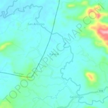
Name: Bankal topographic map, elevation, terrain.

Location: Bankal, Lemery, Iloilo, Western Visayas, Philippines (11.19296 122.85581 11.23296 122.89581)

Average elevation: 94 m

Minimum elevation: 65 m

Maximum elevation: 228 m

Gear up for your next adventure:

💧Filtered Water Bottle - Safe drinking water on the go
📷Outdoor Action Camera - Capture high-elevation views and rugged adventures
🔨Vehicle Emergency Tool - Safety tool for remote road trips to trailheads
🦟Insect Repellent - Keep mosquitoes and black flies away in wooded areas
Backpacking Tent - Lightweight tent for long-distance hiking trips

As an Amazon Associate, this site earns from qualifying purchases at no extra cost to you.