Geolocate

Folignano topographic map

Click on the map to display elevation.

About this map

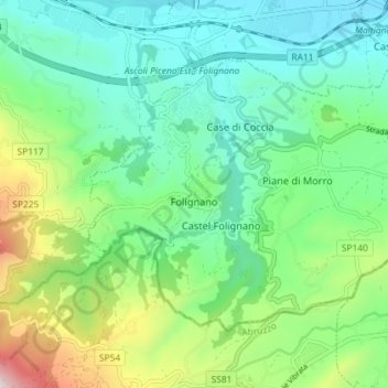
Name: Folignano topographic map, elevation, terrain.

Location: Folignano, Ascoli Piceno, Marche, 63084, Italy (42.80259 13.61458 42.83998 13.68670)

Average elevation: 310 m

Minimum elevation: 66 m

Maximum elevation: 957 m

Other topographic maps

Click on a map to view its topography, its elevation and its terrain.

Petrella

Italy > Marche > Ascoli Piceno > Ripatransone

Average elevation: 241 m

Magazzini

Italy > Marche > Ascoli Piceno > Ripatransone

Average elevation: 147 m

Ponte Tesino

Italy > Marche > Ascoli Piceno > Cossignano

Average elevation: 250 m

San Martino

Italy > Marche > Ascoli Piceno > Castignano

Average elevation: 389 m

Monte Sibilla

Italy > Marche > Ascoli Piceno > Montemonaco

Average elevation: 1,641 m

Gear up for your next adventure:

🪜Heavy Duty Carabiners - Multi-use clips for securing gear to your backpack
🦯Trekking Poles - Reduced impact on joints for steep topographic climbs
🔋Emergency Crank Radio - Weather alerts and power without needing batteries
🌡️Emergency Mylar Blankets - Compact thermal protection for unexpected nights outdoors
🏃Hydration Running Vest - Carry water and maps close to your body for speed

As an Amazon Associate, this site earns from qualifying purchases at no extra cost to you.