
Make a donation
Gear up for your next adventure:
As an Amazon Associate, this site earns from qualifying purchases at no extra cost to you.
Sothonod topographic map
Click on the map to display elevation.
Make a donation
Gear up for your next adventure:
As an Amazon Associate, this site earns from qualifying purchases at no extra cost to you.
About this map
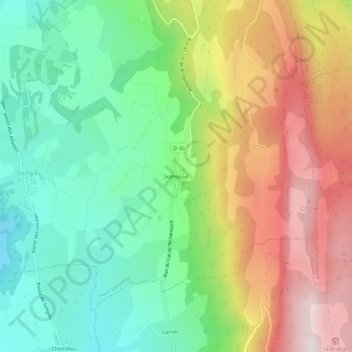
Name: Sothonod topographic map, elevation, terrain.
Average elevation: 921 m
Minimum elevation: 646 m
Maximum elevation: 1,317 m
Make a donation
Gear up for your next adventure:
As an Amazon Associate, this site earns from qualifying purchases at no extra cost to you.
Other topographic maps
Click on a map to view its topography, its elevation and its terrain.
Make a donation
Gear up for your next adventure:
As an Amazon Associate, this site earns from qualifying purchases at no extra cost to you.
Haut Valromey
France > Auvergne-Rhône-Alpes > Ain > Haut Valromey
Plusieurs études ont été menées afin de caractériser les types climatiques auxquels est exposé le territoire national. Les zonages obtenus diffèrent selon les méthodes utilisées, la nature et le nombre des paramètres pris en compte, le maillage territorial des données et la période de référence.…
Average elevation: 905 m