
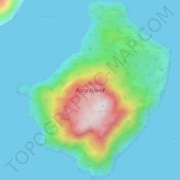
Raza Island topographic map
Interactive map
Click on the map to display elevation.
About this map
Name: Raza Island topographic map, elevation, terrain.
Average elevation: 156 m
Minimum elevation: -3 m
Maximum elevation: 895 m
British Columbia trails, hiking, mountain biking, running and outdoor activities
Other topographic maps
Click on a map to view its topography, its elevation and its terrain.
Dickson Point
Canada > British Columbia > Area B (Discovery Islands/Mainland Inlets)
Average elevation: 62 m
Lillian Russell Creek
Canada > British Columbia > Area B (Discovery Islands/Mainland Inlets)
Average elevation: 270 m