Geolocate

Ellington topographic map

Click on the map to display elevation.

About this map

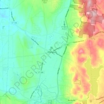
Name: Ellington topographic map, elevation, terrain.

Location: Ellington, Tolland County, Connecticut, 06029, USA (41.86399 -72.50981 41.94399 -72.42981)

Average elevation: 111 m

Minimum elevation: 39 m

Maximum elevation: 258 m

Gear up for your next adventure:

👟Trail Running Shoes - Agile footwear for fast-paced topographic exploration
🥤Collapsible Travel Cup - Saves space and weight in your mess kit
🧰Survival Kit - Essential gear for emergencies in the wilderness
🧶550 Survival Paracord - Versatile utility cord for emergency repairs and rigging
🥾Durable Hiking Shoes - Long-lasting shoes for frequent hiking

As an Amazon Associate, this site earns from qualifying purchases at no extra cost to you.