
Beijing topographic map
Click on the map to display elevation.
Beijing
Beijing is situated at the northern tip of the roughly triangular North China Plain, which opens to the south and east of the city. Mountains to the north, northwest and west shield the city and northern China's agricultural heartland from the encroaching desert steppes. The northwestern part of the municipality, especially Yanqing County and Huairou District, are dominated by the Jundu Mountains, while the western part is framed by Xishan or the Western Hills. The Great Wall of China across the northern part of Beijing Municipality was built on the rugged topography to defend against nomadic incursions from the steppes. Mount Dongling, in the Western Hills and on the border with Hebei, is the municipality's highest point, with an altitude of 2,303 metres (7,556 ft).
About this map
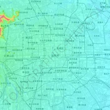
Name: Beijing topographic map, elevation, terrain.
Location: Beijing, Dongcheng District, Beijing, 100010, China (39.74651 116.23124 40.06651 116.55124)
Average elevation: 47 m
Minimum elevation: 19 m
Maximum elevation: 509 m