Geolocate

Sandymount topographic map

Click on the map to display elevation.

About this map

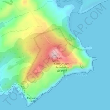
Name: Sandymount topographic map, elevation, terrain.

Location: Sandymount, Dunedin City, Otago, New Zealand (-45.89121 170.67239 -45.89111 170.67249)

Average elevation: 75 m

Minimum elevation: -1 m

Maximum elevation: 312 m

Other topographic maps

Click on a map to view its topography, its elevation and its terrain.

Logan Park

New Zealand > Otago > Dunedin City > Dunedin

Average elevation: 44 m

Waitati River

New Zealand > Otago > Dunedin City > Waitati

Average elevation: 259 m

Otago Harbour

New Zealand > Otago > Dunedin City > Dunedin

Average elevation: 113 m

Dunedin

New Zealand > Otago > Dunedin City

Average elevation: 143 m

Cragieburn

New Zealand > Otago > Dunedin City

Average elevation: 203 m

Gear up for your next adventure:

🪑Ultralight Camping Stool - Compact seating for rest stops during long hikes
🩹Moleskin Blister Pads - Direct protection for painful foot pressure points
🛶Kayak Accessories - Essential gear for safe and fun kayaking adventures
🥾Approach Boots - Comfortable boots for hiking and climbing approaches
🧥Softshell Jacket - Windproof and breathable jacket for hiking

As an Amazon Associate, this site earns from qualifying purchases at no extra cost to you.