
Aurère topographic map
Click on the map to display elevation.
About this map
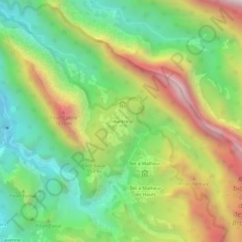
Name: Aurère topographic map, elevation, terrain.
Location: Aurère, La Possession, Saint-Paul, La Réunion, 97419, France (-21.03988 55.40402 -20.99988 55.44402)
Average elevation: 863 m
Minimum elevation: 318 m
Maximum elevation: 1,668 m
Other topographic maps
Click on a map to view its topography, its elevation and its terrain.
Cirque de Mafate
France > La Réunion > La Possession
S'étageant entre 250 m à la confluence de Deux-Bras et 3 019 m au sommet du Gros Morne, le cirque de Mafate présente toute la variation des habitats avec l'altitude.
Average elevation: 1,423 m
Cirque de Mafate
France > La Réunion > La Possession
S'étageant entre 250 m à la confluence de Deux-Bras et 3 019 m au sommet du Gros Morne, le cirque de Mafate présente toute la variation des habitats avec l'altitude.
Average elevation: 1,423 m