Geolocate

Buso-buso topographic map

Click on the map to display elevation.

About this map

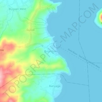
Name: Buso-buso topographic map, elevation, terrain.

Location: Buso-buso, Laurel, Batangas, Calabarzon, 4221, Philippines (14.00354 120.92918 14.04354 120.96918)

Average elevation: 41 m

Minimum elevation: 4 m

Maximum elevation: 186 m

Gear up for your next adventure:

🧥Thermal Fleece Jacket - Versatile insulation for changing mountain temperatures
🦶Hiking Shoe Insoles - Added support for high arches and long days on feet
🧢Outdoor Cap - Protective cap for sun and rain during hikes
💧Reusable Water Bottle - Durable water bottles for hydration on trails
💡Compact LED Flashlight - Powerful and portable flashlight for outdoor use

As an Amazon Associate, this site earns from qualifying purchases at no extra cost to you.