
Thank you for supporting this site ❤️
Make a donation
Make a donation
Gear up for your next adventure:
As an Amazon Associate, this site earns from qualifying purchases at no extra cost to you.
Kechachda topographic map
Click on the map to display elevation.
Thank you for supporting this site ❤️
Make a donation
Make a donation
Gear up for your next adventure:
As an Amazon Associate, this site earns from qualifying purchases at no extra cost to you.
About this map
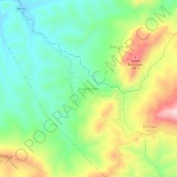
Name: Kechachda topographic map, elevation, terrain.
Location: Kechachda, Bouzeghaia, Zeboudja District, Chlef, Algeria (36.36275 1.29999 36.40275 1.33999)
Average elevation: 341 m
Minimum elevation: 202 m
Maximum elevation: 571 m
Thank you for supporting this site ❤️
Make a donation
Make a donation
Gear up for your next adventure:
As an Amazon Associate, this site earns from qualifying purchases at no extra cost to you.