Geolocate

Coron topographic map

Click on the map to display elevation.

About this map

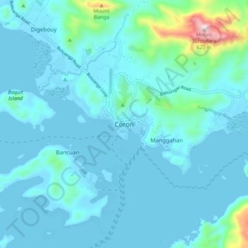
Name: Coron topographic map, elevation, terrain.

Location: Coron, Palawan, Mimaropa, 5316, Philippines (11.95861 120.16517 12.03861 120.24517)

Average elevation: 63 m

Minimum elevation: -3 m

Maximum elevation: 626 m

Other topographic maps

Click on a map to view its topography, its elevation and its terrain.

Apo Island

Philippines > Palawan > Coron

Average elevation: 22 m

Mayanpayan Island

Philippines > Palawan > Coron

Average elevation: 7 m

Coron Island

Philippines > Palawan > Coron

Average elevation: 37 m

Pedrasa Island

Philippines > Palawan > Coron

Average elevation: 18 m

Bulalacao

Philippines > Palawan > Coron

Average elevation: 3 m

Bulalacao

Philippines > Palawan > Coron

Average elevation: 3 m

Gear up for your next adventure:

🔦LED Headlamp - Hands-free lighting for early morning starts or late finishes
🧰Emergency Multi-Tool - Compact multi-tool for outdoor survival
🔥Camping Stove - Portable stoves to cook outdoors with ease
🛁Quick-Dry Microfiber Towel - Space-saving towel that dries rapidly on the move
🧦Hiking Liner Socks - Thin base layer to prevent friction and blisters

As an Amazon Associate, this site earns from qualifying purchases at no extra cost to you.