
Make a donation
Gear up for your next adventure:
As an Amazon Associate, this site earns from qualifying purchases at no extra cost to you.
Juiz de Fora topographic map
Click on the map to display elevation.
Make a donation
Gear up for your next adventure:
As an Amazon Associate, this site earns from qualifying purchases at no extra cost to you.
Juiz de Fora
Although lying within tropical latitudes the climate is relatively mild. The altitude of 700 to 900 m (2,300 to 3,000 ft) makes the weather usually cooler and rainier than the lower surrounding areas. Under the Köppen climate classification Juiz de Fora's climate is classified as a humid subtropical climate with two distinct seasons, one hotter and rainier (October to April) and one cooler and drier (May to September). The average annual temperature is around 19 °C (66 °F) with an average high of 24 °C (75 °F) and an average low of 15 °C (59 °F). It is very humid with average humidity of 80%. The annual rainfall varies between 1,300 and 1,500 mm (51 and 59 in).
Make a donation
Gear up for your next adventure:
As an Amazon Associate, this site earns from qualifying purchases at no extra cost to you.
About this map
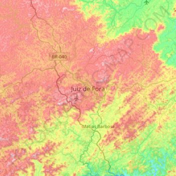
Name: Juiz de Fora topographic map, elevation, terrain.
Average elevation: 675 m
Minimum elevation: 301 m
Maximum elevation: 1,089 m
Make a donation
Gear up for your next adventure:
As an Amazon Associate, this site earns from qualifying purchases at no extra cost to you.
Other topographic maps
Click on a map to view its topography, its elevation and its terrain.
Itamarati
Brazil > Minas Gerais > Região Metropolitana de Belo Horizonte > Belo Horizonte
Average elevation: 831 m