Geolocate

Triós topographic map

Click on the map to display elevation.

About this map

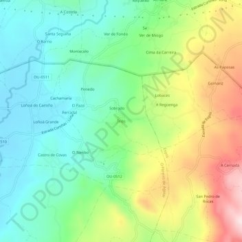
Name: Triós topographic map, elevation, terrain.

Location: Triós, O Pereiro de Aguiar, Orense, Galicia, 32793, España (42.33502 -7.75259 42.37502 -7.71259)

Average elevation: 524 m

Minimum elevation: 372 m

Maximum elevation: 808 m

Other topographic maps

Click on a map to view its topography, its elevation and its terrain.

Chaodarcas

España > Galicia > Orense > O Pereiro de Aguiar

Average elevation: 535 m

Loña

España > Galicia > Orense > O Pereiro de Aguiar > Os Gozos

Average elevation: 359 m

Triós

España > Galicia > Orense > O Pereiro de Aguiar

Average elevation: 487 m

Gear up for your next adventure:

🔭Outdoor Binoculars - Lightweight binoculars for birdwatching and hiking
🧦Merino Wool Socks - Moisture-wicking comfort for long-distance hiking
🎒Hiking Backpack - Lightweight and ergonomic backpacks for day hikes or multi-day treks
🥾Lightweight Hiking Boots - Boots for comfort and mobility on long hikes
🧢Outdoor Visor - Breathable visor for sunny hikes

As an Amazon Associate, this site earns from qualifying purchases at no extra cost to you.