
Make a donation
Gear up for your next adventure:
As an Amazon Associate, this site earns from qualifying purchases at no extra cost to you.
Tahivilla topographic map
Click on the map to display elevation.
Make a donation
Gear up for your next adventure:
As an Amazon Associate, this site earns from qualifying purchases at no extra cost to you.
About this map
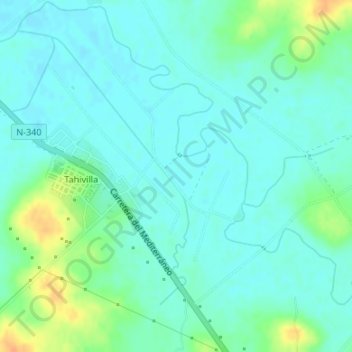
Name: Tahivilla topographic map, elevation, terrain.
Average elevation: 16 m
Minimum elevation: 7 m
Maximum elevation: 41 m
Make a donation
Gear up for your next adventure:
As an Amazon Associate, this site earns from qualifying purchases at no extra cost to you.
Other topographic maps
Click on a map to view its topography, its elevation and its terrain.
Playa de Bolonia
España > Andalucía > Campo de Gibraltar > Tarifa > El Lentiscal
Average elevation: 19 m
Make a donation
Gear up for your next adventure:
As an Amazon Associate, this site earns from qualifying purchases at no extra cost to you.
Sierra de la Plata
España > Andalucía > Campo de Gibraltar > Tarifa > Atlanterra
Average elevation: 162 m
Playa de En Medio o de los Alemanes
España > Andalucía > Campo de Gibraltar > Tarifa > Atlanterra
Average elevation: 53 m