
Make a donation
Gear up for your next adventure:
As an Amazon Associate, this site earns from qualifying purchases at no extra cost to you.
Ventron topographic map
Click on the map to display elevation.
Make a donation
Gear up for your next adventure:
As an Amazon Associate, this site earns from qualifying purchases at no extra cost to you.
About this map
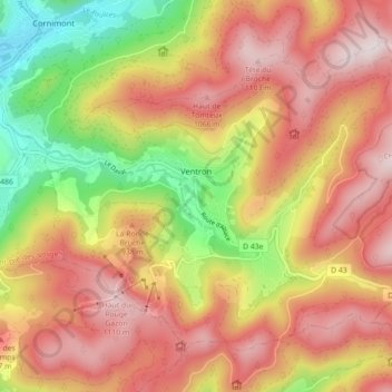
Name: Ventron topographic map, elevation, terrain.
Average elevation: 857 m
Minimum elevation: 502 m
Maximum elevation: 1,131 m
Make a donation
Gear up for your next adventure:
As an Amazon Associate, this site earns from qualifying purchases at no extra cost to you.
Other topographic maps
Click on a map to view its topography, its elevation and its terrain.
Le Haut Rain
Frankrijk > Grand Est > Vogezen > Granges-Aumontzey > La Sténiole
Average elevation: 743 m
Make a donation
Gear up for your next adventure:
As an Amazon Associate, this site earns from qualifying purchases at no extra cost to you.
Col de la Schlucht
Frankrijk > Grand Est > Vogezen > Le Valtin > La Schlucht
Average elevation: 1,068 m
Lac de Longemer
Frankrijk > Grand Est > Vogezen > Xonrupt-Longemer > Les Plombes
Average elevation: 859 m
Make a donation
Gear up for your next adventure:
As an Amazon Associate, this site earns from qualifying purchases at no extra cost to you.
Make a donation
Gear up for your next adventure:
As an Amazon Associate, this site earns from qualifying purchases at no extra cost to you.
Pelouse calcaire du plateau de Beauregard
Frankrijk > Grand Est > Vogezen > Maxey-sur-Meuse
Average elevation: 342 m
Make a donation
Gear up for your next adventure:
As an Amazon Associate, this site earns from qualifying purchases at no extra cost to you.