Geolocate

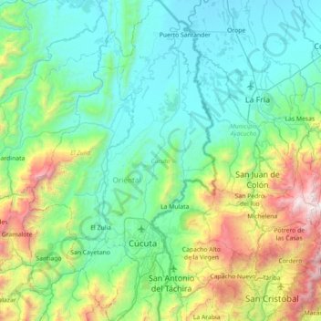
Cúcuta topographic map

Click on the map to display elevation.

Cúcuta

The city is in the eastern part of the Department of North Santander, in the Cordillera Oriental, close to the border with Venezuela. The city's area is 110 square kilometres (42 square miles) and its elevation is 320 metres (1,050 feet) above sea level.

Wikipedia (CC-BY-SA 3.0)

About this map

Name: Cúcuta topographic map, elevation, terrain.

Location: Cúcuta, Oriental, Norte de Santander, RAP Gran Santander, Colombia (7.72599 -72.60683 8.42925 -72.34538)

Average elevation: 591 m

Minimum elevation: 40 m

Maximum elevation: 2,778 m

Gear up for your next adventure:

🧢Outdoor Visor - Breathable visor for sunny hikes
🧥Waterproof Jacket - Lightweight rain jackets for hiking and outdoor activities
🥾Mountain Hiking Boots - High-traction boots for rocky terrain
🥾Hiking Boots - Sturdy boots providing ankle support and traction on rugged trails
🔋Emergency Crank Radio - Weather alerts and power without needing batteries

As an Amazon Associate, this site earns from qualifying purchases at no extra cost to you.