
Make a donation
Gear up for your next adventure:
As an Amazon Associate, this site earns from qualifying purchases at no extra cost to you.
Puerto Ocopa topographic map
Click on the map to display elevation.
Make a donation
Gear up for your next adventure:
As an Amazon Associate, this site earns from qualifying purchases at no extra cost to you.
Puerto Ocopa
Es una de las comunidades nativas más grandes con las que cuenta el distrito de Río Tambo. Se encuentra a una altitud de 358 m s. n. m.
Make a donation
Gear up for your next adventure:
As an Amazon Associate, this site earns from qualifying purchases at no extra cost to you.
About this map
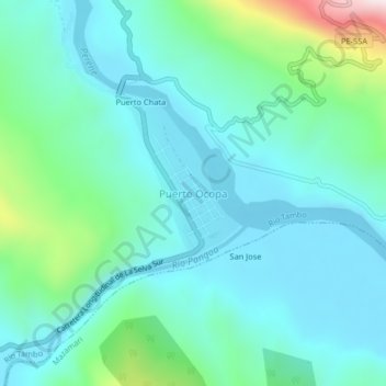
Name: Puerto Ocopa topographic map, elevation, terrain.
Location: Puerto Ocopa, Río Tambo, Satipo, Junín, Perú (-11.16464 -74.32812 -11.12464 -74.28812)
Average elevation: 428 m
Minimum elevation: 307 m
Maximum elevation: 930 m
Make a donation
Gear up for your next adventure:
As an Amazon Associate, this site earns from qualifying purchases at no extra cost to you.