Geolocate

Randa topographic map

Click on the map to display elevation.

About this map

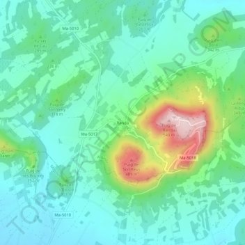
Name: Randa topographic map, elevation, terrain.

Location: Randa, Algaida, Pla de Mallorca, Islas Baleares, 07210, España (39.50676 2.89504 39.54676 2.93504)

Average elevation: 263 m

Minimum elevation: 171 m

Maximum elevation: 545 m

Gear up for your next adventure:

🧥Thermal Layer - Insulating layer for cold outdoor conditions
🧦Crew Hiking Socks - Comfortable socks for long-distance hikes
💧Hydration Bladder - Hands-free hydration solution for long treks
🚲Bike Repair Kit - Essential tools for on-trail mechanical issues
🧢Hiking Hat - Sun-protective and breathable hats for long treks

As an Amazon Associate, this site earns from qualifying purchases at no extra cost to you.