Geolocate

Wixom topographic map

Click on the map to display elevation.

About this map

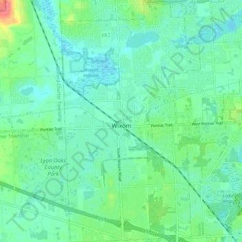
Name: Wixom topographic map, elevation, terrain.

Location: Wixom, Oakland County, Michigan, United States (42.49317 -83.55867 42.55856 -83.50744)

Average elevation: 288 m

Minimum elevation: 272 m

Maximum elevation: 340 m

Gear up for your next adventure:

🔭Outdoor Binoculars - Lightweight binoculars for birdwatching and hiking
🔋Lithium AA Batteries - Long-lasting power that performs in extreme cold
🦌Outdoor Trail Camera - Monitor wildlife activity near your favorite spots
🥾Light Trekking Boots - Supportive boots for multi-day treks
🧭GPS Outdoor Watch - Smart watch for navigation and fitness tracking in nature

As an Amazon Associate, this site earns from qualifying purchases at no extra cost to you.