
Thank you for supporting this site ❤️
Make a donation
Make a donation
Gear up for your next adventure:
As an Amazon Associate, this site earns from qualifying purchases at no extra cost to you.
uttardug topographic map
Click on the map to display elevation.
Thank you for supporting this site ❤️
Make a donation
Make a donation
Gear up for your next adventure:
As an Amazon Associate, this site earns from qualifying purchases at no extra cost to you.
About this map
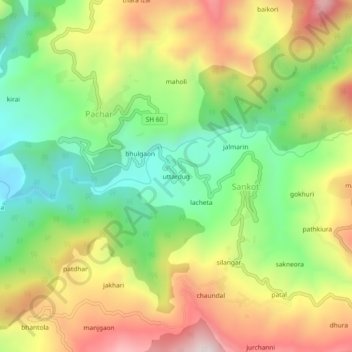
Name: uttardug topographic map, elevation, terrain.
Location: uttardug, Sankot, Kanda, Bageshwar, Uttarakhand, 263640, India (29.85983 79.95138 29.89983 79.99138)
Average elevation: 1,528 m
Minimum elevation: 1,210 m
Maximum elevation: 1,925 m
Thank you for supporting this site ❤️
Make a donation
Make a donation
Gear up for your next adventure:
As an Amazon Associate, this site earns from qualifying purchases at no extra cost to you.