
Make a donation
Gear up for your next adventure:
As an Amazon Associate, this site earns from qualifying purchases at no extra cost to you.
Potomac River topographic map
Click on the map to display elevation.
Make a donation
Gear up for your next adventure:
As an Amazon Associate, this site earns from qualifying purchases at no extra cost to you.
About this map
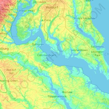
Name: Potomac River topographic map, elevation, terrain.
Location: Potomac River, Charles County, Maryland, United States (37.89021 -77.32647 38.61959 -76.23597)
Average elevation: 26 m
Minimum elevation: -5 m
Maximum elevation: 152 m
Make a donation
Gear up for your next adventure:
As an Amazon Associate, this site earns from qualifying purchases at no extra cost to you.
Other topographic maps
Click on a map to view its topography, its elevation and its terrain.
Myrtle Grove Estates
United States > Maryland > Charles County > Myrtle Grove Estates
Average elevation: 40 m
Country Club South
United States > Maryland > Charles County > Waldorf > Country Club South
Average elevation: 63 m
Make a donation
Gear up for your next adventure:
As an Amazon Associate, this site earns from qualifying purchases at no extra cost to you.