
Thank you for supporting this site ❤️
Make a donation
Make a donation
Gear up for your next adventure:
As an Amazon Associate, this site earns from qualifying purchases at no extra cost to you.
Arco topographic map
Click on the map to display elevation.
Thank you for supporting this site ❤️
Make a donation
Make a donation
Gear up for your next adventure:
As an Amazon Associate, this site earns from qualifying purchases at no extra cost to you.
Arco
Arco Peak, located two mile north of the community at an elevation of 7547 feet, rises 2220 feet above the city.
Thank you for supporting this site ❤️
Make a donation
Make a donation
Gear up for your next adventure:
As an Amazon Associate, this site earns from qualifying purchases at no extra cost to you.
About this map
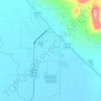
Name: Arco topographic map, elevation, terrain.
Location: Arco, Butte County, Idaho, 83213, United States (43.61681 -113.31116 43.64392 -113.29116)
Average elevation: 1,634 m
Minimum elevation: 1,613 m
Maximum elevation: 1,800 m
Thank you for supporting this site ❤️
Make a donation
Make a donation
Gear up for your next adventure:
As an Amazon Associate, this site earns from qualifying purchases at no extra cost to you.