Geolocate

Lewin topographic map

Click on the map to display elevation.

About this map

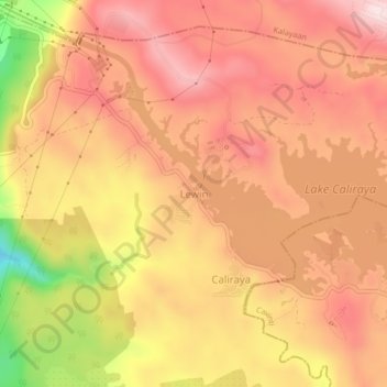
Name: Lewin topographic map, elevation, terrain.

Location: Lewin, Lumban, Laguna, Calabarzon, 4014, Philippines (14.27590 121.47592 14.31590 121.51592)

Average elevation: 272 m

Minimum elevation: 34 m

Maximum elevation: 393 m

Other topographic maps

Click on a map to view its topography, its elevation and its terrain.

Wawa

Philippines > Laguna > Lumban

Average elevation: 34 m

Lake Caliraya

Philippines > Laguna > Lumban > Lewin

Average elevation: 255 m

Lake Caliraya

Philippines > Laguna > Lumban > Lewin

Average elevation: 255 m

Gear up for your next adventure:

🌬️Windproof Camp Stove - Efficient cooking even on exposed mountain peaks
🧢Hiking Hat - Sun-protective and breathable hats for long treks
🛌Down Sleeping Bag - Superior warmth-to-weight ratio for cold nights
🧴Sunscreen SPF - Broad-spectrum sunscreen for outdoor activities
🥾Trail Hiking Boots - Supportive boots for rough trails

As an Amazon Associate, this site earns from qualifying purchases at no extra cost to you.