
San Gabriel topographic map
Click on the map to display elevation.
About this map
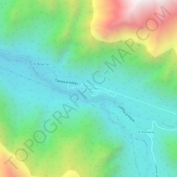
Name: San Gabriel topographic map, elevation, terrain.
Average elevation: 1,638 m
Minimum elevation: 1,180 m
Maximum elevation: 2,768 m
Other topographic maps
Click on a map to view its topography, its elevation and its terrain.
Parque Natural El Yeso-Laguna Negra
Chile > Región Metropolitana de Santiago > Provincia de Cordillera > San José de Maipo
Average elevation: 2,942 m
Monumento Natural El Morado
Chile > Región Metropolitana de Santiago > Provincia de Cordillera > San José de Maipo
Average elevation: 2,915 m
Museo
Chile > Región Metropolitana de Santiago > Provincia de Cordillera > San José de Maipo
Average elevation: 3,370 m