Geolocate

Aying topographic map

Click on the map to display elevation.

About this map

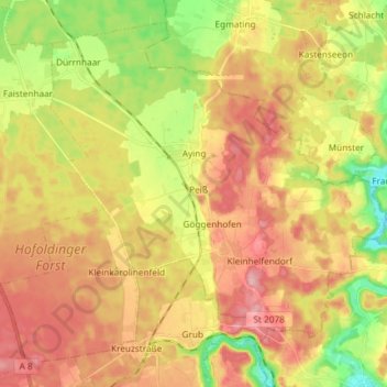
Name: Aying topographic map, elevation, terrain.

Location: Aying, Landkreis München, Bavaria, 85653, Germany (47.91593 11.70497 48.00339 11.85209)

Average elevation: 621 m

Minimum elevation: 548 m

Maximum elevation: 683 m

Gear up for your next adventure:

🧤Rechargeable Heated Gloves - Extreme warmth for Canadian winter expeditions
🧊Insulated Water Bottle - Keeps drinks cold in summer and prevents freezing in winter
🥾Waterproof Hiking Boots - Essential footwear for rugged terrain and wet Canadian trails
🧢Sun Hat - Wide-brim hat for sun protection
🥾Lightweight Hiking Shoes - Comfortable shoes for day hikes

As an Amazon Associate, this site earns from qualifying purchases at no extra cost to you.