Geolocate

Schertz topographic map

Click on the map to display elevation.

About this map

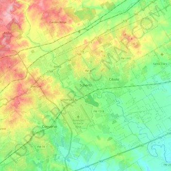
Name: Schertz topographic map, elevation, terrain.

Location: Schertz, Guadalupe County, Texas, 78154, United States (29.46805 -98.30602 29.65928 -98.17674)

Average elevation: 232 m

Minimum elevation: 174 m

Maximum elevation: 331 m

Other topographic maps

Click on a map to view its topography, its elevation and its terrain.

Haeckerville

United States > Texas > Guadalupe County > Cibolo

Average elevation: 213 m

Zorn

United States > Texas > Guadalupe County

Average elevation: 169 m

Gear up for your next adventure:

Lightweight Camping Tent - Portable shelter optimized for Canadian backcountry camping
🎒Hiking Backpack - Lightweight and ergonomic backpacks for day hikes or multi-day treks
🧴Outdoor Sunscreen - High SPF protection for high-altitude UV exposure
🥾Trekking Poles - Adjustable trekking poles to reduce knee stress and improve stability
🛌Insulated Sleeping Pad - Critical thermal barrier between you and the cold ground

As an Amazon Associate, this site earns from qualifying purchases at no extra cost to you.