Geolocate

Tagkawayan topographic map

Click on the map to display elevation.

About this map

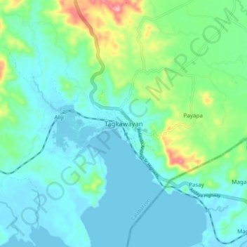
Name: Tagkawayan topographic map, elevation, terrain.

Location: Tagkawayan, Quezon, Calabarzon, 4321C, Philippines (13.92561 122.49921 14.00561 122.57921)

Average elevation: 40 m

Minimum elevation: -3 m

Maximum elevation: 200 m

Gear up for your next adventure:

🚲Bike Repair Kit - Essential tools for on-trail mechanical issues
🧢Beanie Hat - Keep your head warm in cold weather
🧶550 Survival Paracord - Versatile utility cord for emergency repairs and rigging
💧Reusable Water Bottle - Durable water bottles for hydration on trails
🏃Hydration Running Vest - Carry water and maps close to your body for speed

As an Amazon Associate, this site earns from qualifying purchases at no extra cost to you.