
Make a donation
Gear up for your next adventure:
As an Amazon Associate, this site earns from qualifying purchases at no extra cost to you.
Lourdes topographic map
Click on the map to display elevation.
Make a donation
Gear up for your next adventure:
As an Amazon Associate, this site earns from qualifying purchases at no extra cost to you.
Lourdes
Lourdes lies at an elevation of 420 m (1,380 ft) and in a central position through which runs the fast-flowing river Gave de Pau from the south, coming from its source at Gavarnie; into it flow several smaller rivers from Barèges and Cauterets. The Gave then branches off to the west towards the Béarn, running past the banks of the Grotto and on downstream to Pau and then Biarritz.
Make a donation
Gear up for your next adventure:
As an Amazon Associate, this site earns from qualifying purchases at no extra cost to you.
About this map
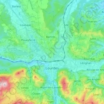
Name: Lourdes topographic map, elevation, terrain.
Average elevation: 514 m
Minimum elevation: 358 m
Maximum elevation: 1,082 m
Make a donation
Gear up for your next adventure:
As an Amazon Associate, this site earns from qualifying purchases at no extra cost to you.