
Make a donation
Gear up for your next adventure:
As an Amazon Associate, this site earns from qualifying purchases at no extra cost to you.
Slavkov u Brna topographic map
Click on the map to display elevation.
Make a donation
Gear up for your next adventure:
As an Amazon Associate, this site earns from qualifying purchases at no extra cost to you.
About this map
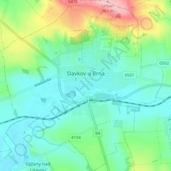
Name: Slavkov u Brna topographic map, elevation, terrain.
Average elevation: 239 m
Minimum elevation: 195 m
Maximum elevation: 361 m
Make a donation
Gear up for your next adventure:
As an Amazon Associate, this site earns from qualifying purchases at no extra cost to you.
Other topographic maps
Click on a map to view its topography, its elevation and its terrain.
Rychtářov
Czechia > South Moravian Region > Vyškov
Rychtářov (German: Richtersdorf) is a former village, today a part of the town of Vyškov in the South Moravian Region of the Czech Republic. Located approximately 10 kilometres (6 mi) north of Vyškov and 27 kilometres (17 mi) north-east of Brno, it lies at an altitude of 401 m above sea level. Rychtářov…
Average elevation: 402 m