
Make a donation
Gear up for your next adventure:
As an Amazon Associate, this site earns from qualifying purchases at no extra cost to you.
Godbout topographic map
Click on the map to display elevation.
Make a donation
Gear up for your next adventure:
As an Amazon Associate, this site earns from qualifying purchases at no extra cost to you.
About this map
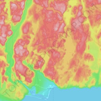
Name: Godbout topographic map, elevation, terrain.
Location: Godbout, Manicouagan, Côte-Nord, Quebec, G0H 1G0, Canada (49.30658 -67.67680 49.44175 -67.47275)
Average elevation: 148 m
Minimum elevation: -4 m
Maximum elevation: 271 m
Manicouagan trails, hiking, mountain biking, running and outdoor activities
Make a donation
Gear up for your next adventure:
As an Amazon Associate, this site earns from qualifying purchases at no extra cost to you.
Other topographic maps
Click on a map to view its topography, its elevation and its terrain.
Make a donation
Gear up for your next adventure:
As an Amazon Associate, this site earns from qualifying purchases at no extra cost to you.