Geolocate

Haflong topographic map

Click on the map to display elevation.

About this map

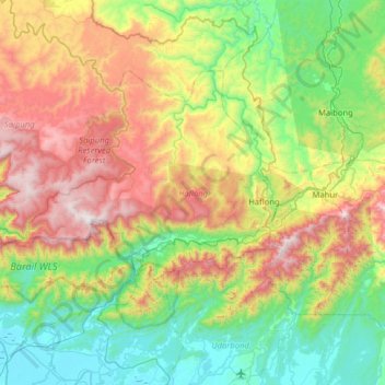
Name: Haflong topographic map, elevation, terrain.

Location: Haflong, Dima Hasao district, Assam, India (25.00055 92.52051 25.36443 93.15428)

Average elevation: 576 m

Minimum elevation: 13 m

Maximum elevation: 1,698 m

Gear up for your next adventure:

💧Reusable Water Bottle - Durable water bottles for hydration on trails
💧Collapsible Water Bottle - Space-saving water bottle for outdoor activities
🔦UV Flashlight - Detect minerals or specific insects in the dark
🏕️Camping Hammock - Integrated protection for sleeping between trees
🛰️Satellite Messenger - Emergency communication for areas with no cell service

As an Amazon Associate, this site earns from qualifying purchases at no extra cost to you.