Geolocate

Kaytapos topographic map

Click on the map to display elevation.

About this map

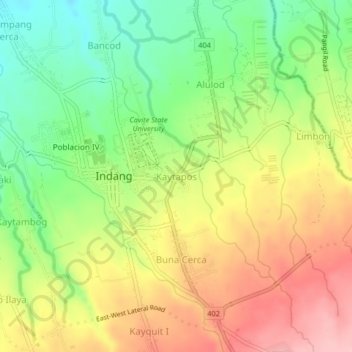
Name: Kaytapos topographic map, elevation, terrain.

Location: Kaytapos, Indang, Cavite, Calabarzon, 4122, Philippines (14.17579 120.86563 14.21579 120.90563)

Average elevation: 307 m

Minimum elevation: 229 m

Maximum elevation: 391 m

Other topographic maps

Click on a map to view its topography, its elevation and its terrain.

Bancod

Philippines > Cavite > Indang

Average elevation: 241 m

Kaytapos

Philippines > Cavite > Indang

Average elevation: 308 m

Gear up for your next adventure:

🧥Ultralight Puffy Jacket - Maximum warmth that packs down to the size of an orange
🪑Ultralight Camping Stool - Compact seating for rest stops during long hikes
🛶Canoe Life Vest - Safety vest for water sports
🧰Survival Kit - Essential gear for emergencies in the wilderness
🔦LED Headlamp - Hands-free lighting for early morning starts or late finishes

As an Amazon Associate, this site earns from qualifying purchases at no extra cost to you.