Geolocate

Bidar topographic map

Click on the map to display elevation.

About this map

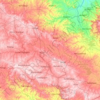
Name: Bidar topographic map, elevation, terrain.

Location: Bidar, Bidar district, Karnataka, India (17.38333 76.63333 18.78333 78.03333)

Average elevation: 536 m

Minimum elevation: 336 m

Maximum elevation: 694 m

Gear up for your next adventure:

🐕Hiking Dog Pack - Let your canine companion carry their own water and food
👟Leg Gaiters - Keep debris, mud, and snow out of your boots
🥤Collapsible Travel Cup - Saves space and weight in your mess kit
🧣Evaporative Cooling Towel - Beat the heat during intense summer climbs
🥾Approach Shoes - Shoes designed for climbing approaches and rugged trails

As an Amazon Associate, this site earns from qualifying purchases at no extra cost to you.