Geolocate

Matagorda County topographic map

Click on the map to display elevation.

About this map

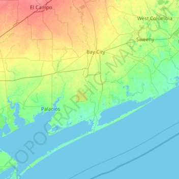
Name: Matagorda County topographic map, elevation, terrain.

Location: Matagorda County, Texas, United States (28.29223 -96.38043 29.22977 -95.42099)

Average elevation: 8 m

Minimum elevation: -2 m

Maximum elevation: 38 m

Other topographic maps

Click on a map to view its topography, its elevation and its terrain.

Ashwood

United States > Texas > Matagorda County > Ashwood

Average elevation: 16 m

Gear up for your next adventure:

🔭Outdoor Binoculars - Lightweight binoculars for birdwatching and hiking
🥾Hiking Shorts - Breathable shorts suitable for summer hikes
🧥Waterproof Jacket - Lightweight rain jackets for hiking and outdoor activities
🚑Survival Whistle - Signal for help across long distances in mountains
🔋Emergency Crank Radio - Weather alerts and power without needing batteries

As an Amazon Associate, this site earns from qualifying purchases at no extra cost to you.