Geolocate

Osmaston topographic map

Click on the map to display elevation.

About this map

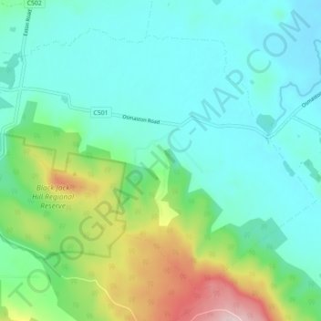
Name: Osmaston topographic map, elevation, terrain.

Location: Osmaston, Meander Valley, Tasmania, Australia (-41.59759 146.72168 -41.54324 146.80945)

Average elevation: 264 m

Minimum elevation: 172 m

Maximum elevation: 559 m

Gear up for your next adventure:

🧴First Aid Kit - Essential first aid supplies for outdoor emergencies
Camping Tent - Weather-resistant tents suitable for 2 to 6 people
🦟Insect Repellent - Keep mosquitoes and black flies away in wooded areas
🚲Handlebar Phone Mount - View topographic-map.com live while cycling
🔥Emergency Fire Starter - Reliable ignition source for all weather conditions

As an Amazon Associate, this site earns from qualifying purchases at no extra cost to you.