Geolocate

La Retuerta topographic map

Click on the map to display elevation.

About this map

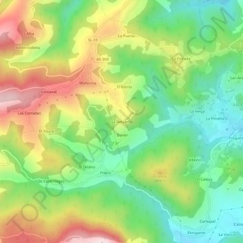
Name: La Retuerta topographic map, elevation, terrain.

Location: La Retuerta, Mallecina, Salas, Asturias, 33867, España (43.42222 -6.26839 43.46222 -6.22839)

Average elevation: 389 m

Minimum elevation: 188 m

Maximum elevation: 679 m

Gear up for your next adventure:

🧥Fleece Jacket - Warm and lightweight jacket for layering
🛰️Satellite Messenger - Emergency communication for areas with no cell service
🧰Emergency Multi-Tool - Compact multi-tool for outdoor survival
🧊Portable Cooler - Keep food and drinks cold during outdoor adventures
💧Reusable Water Bottle - Durable water bottles for hydration on trails

As an Amazon Associate, this site earns from qualifying purchases at no extra cost to you.