Geolocate

Beroun topographic map

Click on the map to display elevation.

About this map
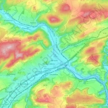
Name: Beroun topographic map, elevation, terrain.

Location: Beroun, okres Beroun, Central Bohemian Region, Central Bohemia, 266 01, Czechia (49.93338 14.02178 50.00359 14.14008)

Average elevation: 318 m

Minimum elevation: 211 m

Maximum elevation: 482 m

Other topographic maps

Click on a map to view its topography, its elevation and its terrain.

Studce

Czechia > Central Bohemian Region

Average elevation: 235 m

Trojhran

Czechia > Central Bohemian Region > Žehrov

Average elevation: 285 m

Mezivrata

Czechia > Central Bohemian Region > Neustupov

Average elevation: 630 m

Gear up for your next adventure:

🔪Outdoor Multitool - Versatile tool for repairs and food prep in the wild
🧥Insulated Jacket - Keep warm in cold outdoor conditions
🧳Compression Sacks - Maximize space in your backpack by shrinking gear
🥫Freeze-Dried Meals - Lightweight, high-calorie nutrition for multi-day treks
⛺Lightweight Camping Tent - Portable shelter optimized for Canadian backcountry camping

As an Amazon Associate, this site earns from qualifying purchases at no extra cost to you.