Geolocate

Fairfield topographic map

Click on the map to display elevation.

About this map

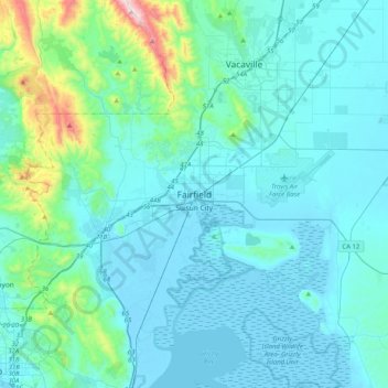
Name: Fairfield topographic map, elevation, terrain.

Location: Fairfield, Solano County, California, 94533, United States (38.08936 -122.19997 38.40936 -121.87997)

Average elevation: 94 m

Minimum elevation: -4 m

Maximum elevation: 851 m

Gear up for your next adventure:

🥾Trail Hiking Socks - Comfortable socks to prevent blisters and fatigue
🥾Mountain Trail Shoes - High-traction shoes for mountain trails
🧤Insulated Winter Gloves - Heavy-duty protection for sub-zero Canadian adventures
🧦Thermal Socks - Warm socks for winter hiking or camping
🥾Light Trekking Boots - Supportive boots for multi-day treks

As an Amazon Associate, this site earns from qualifying purchases at no extra cost to you.