
Make a donation
Gear up for your next adventure:
As an Amazon Associate, this site earns from qualifying purchases at no extra cost to you.
Gap topographic map
Click on the map to display elevation.
Make a donation
Gear up for your next adventure:
As an Amazon Associate, this site earns from qualifying purchases at no extra cost to you.
Gap
Située sur la route Napoléon (RN 85) qui emprunte le col Bayard au nord de la ville, Gap se trouve au sud-est du Dauphiné, au nord de la région Provence-Alpes-Côte d'Azur. Avec ses 40 631 habitants (2019), elle est la principale commune d'une aire urbaine de 63 487 habitants (2015), qui est la principale agglomération des Alpes du Sud. À 750 mètres d'altitude, Gap est au sud-ouest du parc national des Écrins, au sud-est du massif du Dévoluy, à l'ouest du lac de Serre-Ponçon et au nord de la Durance.
Make a donation
Gear up for your next adventure:
As an Amazon Associate, this site earns from qualifying purchases at no extra cost to you.
About this map
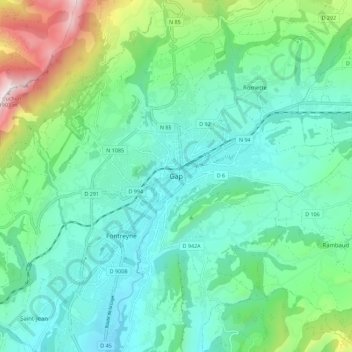
Name: Gap topographic map, elevation, terrain.
Average elevation: 956 m
Minimum elevation: 674 m
Maximum elevation: 1,892 m
Make a donation
Gear up for your next adventure:
As an Amazon Associate, this site earns from qualifying purchases at no extra cost to you.