Geolocate

Skudai topographic map

Click on the map to display elevation.

About this map

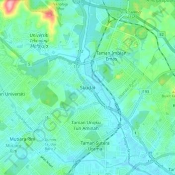
Name: Skudai topographic map, elevation, terrain.

Location: Skudai, Iskandar Puteri, Johor Bahru, Johor, 81210, Malaysia (1.49697 103.62210 1.57697 103.70210)

Average elevation: 29 m

Minimum elevation: 2 m

Maximum elevation: 149 m

Other topographic maps

Click on a map to view its topography, its elevation and its terrain.

Tebrau River

Malaysia > Johor > Iskandar Puteri

Average elevation: 34 m

Pulai River

Malaysia > Johor > Iskandar Puteri

Average elevation: 12 m

Sungai Sekudai

Malaysia > Johor > Iskandar Puteri

Average elevation: 14 m

Kampung Sepakat Baru

Malaysia > Johor > Iskandar Puteri

Average elevation: 23 m

Tebrau River

Malaysia > Johor > Iskandar Puteri

Average elevation: 34 m

Aspira LakeHomes

Malaysia > Johor > Iskandar Puteri

Average elevation: 27 m

Sungai Melayu

Malaysia > Johor > Iskandar Puteri

Average elevation: 15 m

Tasik Hati

Malaysia > Johor > Iskandar Puteri > Pulai

Average elevation: 26 m

Gear up for your next adventure:

🧶550 Survival Paracord - Versatile utility cord for emergency repairs and rigging
🧴Sunscreen SPF - Broad-spectrum sunscreen for outdoor activities
🔋Solar Power Bank - Keep your GPS and devices charged during long outdoor trips
🦟Insect Repellent - Keep mosquitoes and black flies away in wooded areas
🥾Waterproof Hiking Boots - Essential footwear for rugged terrain and wet Canadian trails

As an Amazon Associate, this site earns from qualifying purchases at no extra cost to you.