Geolocate

Varzi topographic map

Click on the map to display elevation.

About this map

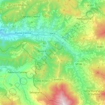
Name: Varzi topographic map, elevation, terrain.

Location: Varzi, Pavia, Lombardy, 27057, Italy (44.75235 9.15000 44.85654 9.28729)

Average elevation: 651 m

Minimum elevation: 307 m

Maximum elevation: 1,382 m

Gear up for your next adventure:

Tent Footprint - Protect tent floor and increase durability
🥾Hiking Leggings - Comfortable leggings for outdoor activities
🧥Insulated Jacket - Keep warm in cold outdoor conditions
🚲Handlebar Phone Mount - View topographic-map.com live while cycling
🧤Rechargeable Heated Gloves - Extreme warmth for Canadian winter expeditions

As an Amazon Associate, this site earns from qualifying purchases at no extra cost to you.