Geolocate

Nashua topographic map

Click on the map to display elevation.

About this map

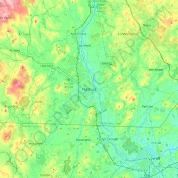
Name: Nashua topographic map, elevation, terrain.

Location: Nashua, Hillsborough County, New Hampshire, 03060-03064, United States (42.60563 -71.62770 42.92563 -71.30770)

Average elevation: 82 m

Minimum elevation: 13 m

Maximum elevation: 284 m

Other topographic maps

Click on a map to view its topography, its elevation and its terrain.

Gear up for your next adventure:

🏕️Camping Hammock - Integrated protection for sleeping between trees
🧼Biodegradable Camp Soap - Environmentally friendly cleaning for gear and body
🧦Hiking Socks - Moisture-wicking and comfortable socks for long hikes
🔨Vehicle Emergency Tool - Safety tool for remote road trips to trailheads
🪑Ultralight Camping Stool - Compact seating for rest stops during long hikes

As an Amazon Associate, this site earns from qualifying purchases at no extra cost to you.