Geolocate

Knivsta topographic map

Click on the map to display elevation.

About this map

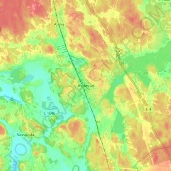
Name: Knivsta topographic map, elevation, terrain.

Location: Knivsta, Knivsta kommun, Uppsala County, 74139, Sweden (59.68791 17.74817 59.76791 17.82817)

Average elevation: 26 m

Minimum elevation: 0 m

Maximum elevation: 55 m

Gear up for your next adventure:

🔭Compact Binoculars - Lightweight optics for scouting trails and wildlife
🥽Outdoor Goggles - Protective eyewear for outdoor activities
🚲Handlebar Phone Mount - View topographic-map.com live while cycling
🧥Softshell Hiking Jacket - The perfect balance of wind protection and breathability
Camping Essentials - All-in-one gear for a comfortable camping trip

As an Amazon Associate, this site earns from qualifying purchases at no extra cost to you.