Geolocate

Ampfing topographic map

Click on the map to display elevation.

About this map

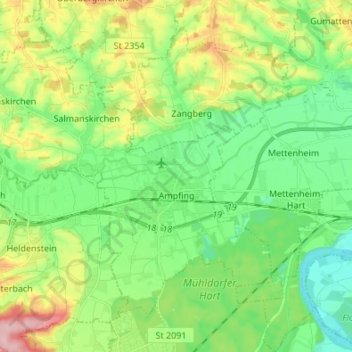
Name: Ampfing topographic map, elevation, terrain.

Location: Ampfing, Landkreis Mühldorf am Inn, Bavaria, 84539, Germany (48.22401 12.32045 48.29585 12.45590)

Average elevation: 433 m

Minimum elevation: 378 m

Maximum elevation: 544 m

Other topographic maps

Click on a map to view its topography, its elevation and its terrain.

Geier

Germany > Bavaria > Landkreis Mühldorf am Inn > Polling > Geier

Average elevation: 454 m

Gear up for your next adventure:

🥾Durable Hiking Shoes - Long-lasting shoes for frequent hiking
🥾Hiking Shorts - Breathable shorts suitable for summer hikes
🔭Outdoor Binoculars - Lightweight binoculars for birdwatching and hiking
💡LED Headlamp - Hands-free illumination for night hiking and camping
🦯Trekking Poles - Reduced impact on joints for steep topographic climbs

As an Amazon Associate, this site earns from qualifying purchases at no extra cost to you.