
Make a donation
Gear up for your next adventure:
As an Amazon Associate, this site earns from qualifying purchases at no extra cost to you.
Royan topographic map
Click on the map to display elevation.
Make a donation
Gear up for your next adventure:
As an Amazon Associate, this site earns from qualifying purchases at no extra cost to you.
About this map
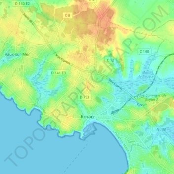
Name: Royan topographic map, elevation, terrain.
Average elevation: 13 m
Minimum elevation: -2 m
Maximum elevation: 36 m
Make a donation
Gear up for your next adventure:
As an Amazon Associate, this site earns from qualifying purchases at no extra cost to you.
Other topographic maps
Click on a map to view its topography, its elevation and its terrain.
La Basse Coudre
Frankrijk > Nieuw-Aquitanië > Charente-Maritime > Tonnay-Charente
Average elevation: 4 m
Make a donation
Gear up for your next adventure:
As an Amazon Associate, this site earns from qualifying purchases at no extra cost to you.
Lavaud
Frankrijk > Nieuw-Aquitanië > Charente-Maritime > Réaux-sur-Trèfle > Lavaud
Average elevation: 44 m
L'Île d'Albe
Frankrijk > Nieuw-Aquitanië > Charente-Maritime > Muron > L'Île d'Albe
Average elevation: 3 m
Make a donation
Gear up for your next adventure:
As an Amazon Associate, this site earns from qualifying purchases at no extra cost to you.