Geolocate

Manapparai topographic map

Click on the map to display elevation.

About this map

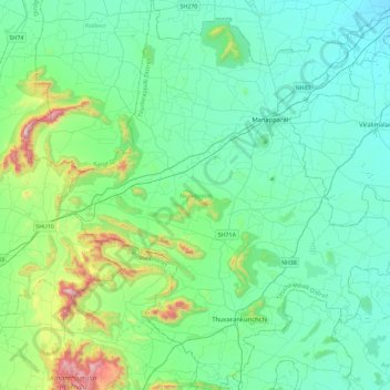
Name: Manapparai topographic map, elevation, terrain.

Location: Manapparai, Tiruchirappalli District, Tamil Nadu, India (10.29359 78.17287 10.74629 78.63418)

Average elevation: 255 m

Minimum elevation: 97 m

Maximum elevation: 991 m

Other topographic maps

Click on a map to view its topography, its elevation and its terrain.

Manapparai

India > Tamil Nadu > Manapparai

Average elevation: 161 m

Thoppampatti

India > Tamil Nadu > Manapparai > Annampatty

Average elevation: 181 m

Kannudayanpatti

India > Tamil Nadu > Manapparai

Average elevation: 136 m

Marungapuri

India > Tamil Nadu > Manapparai

Average elevation: 249 m

Annanagar

India > Tamil Nadu > Manapparai > Vembanur

Average elevation: 148 m

Gear up for your next adventure:

🧢Sun Protection Cap - Breathable cap to protect from sun exposure
🧢Outdoor Cap - Protective cap for sun and rain during hikes
🥽Outdoor Goggles - Protective eyewear for outdoor activities
🧭Orienteering Kit - Tools for map reading and navigation in the wild
🔭Compact Monocular - One-handed bird watching and trail spotting

As an Amazon Associate, this site earns from qualifying purchases at no extra cost to you.