
Ciumbuleuit topographic map
Interactive map
Click on the map to display elevation.
About this map
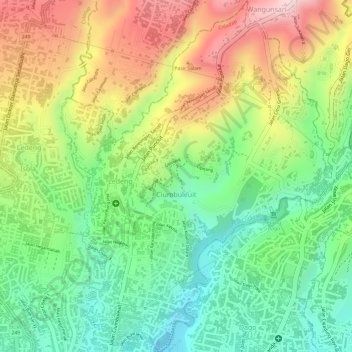
Name: Ciumbuleuit topographic map, elevation, terrain.
Average elevation: 898 m
Minimum elevation: 765 m
Maximum elevation: 1,061 m
Other topographic maps
Click on a map to view its topography, its elevation and its terrain.
Cipedes
Indonésie > Java occidental > Bandung
Cipedes, Sukasari, Bandung, Java occidental, Jawa, 40162, Indonésie
Average elevation: 786 m
Jatisari
Indonésie > Java occidental > Bandung
Jatisari, Buahbatu, Bandung, Java occidental, Indonésie
Average elevation: 677 m
Gunung Patuha
Indonésie > Java occidental > Bandung
Gunung Patuha, Bandung, Java occidental, 40973, Indonésie
Average elevation: 2,103 m
Kamojang, Kawah
Indonésie > Java occidental > Bandung
Kamojang, Kawah, Bandung, Java occidental, Indonésie
Average elevation: 1,589 m
Gunung Kendang
Indonésie > Java occidental > Bandung
Gunung Kendang, Bandung, Java occidental, Indonésie
Average elevation: 2,284 m