
Kaliurang topographic map
Click on the map to display elevation.
About this map
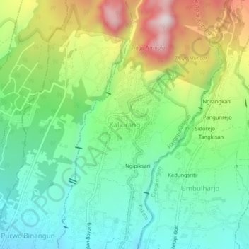
Name: Kaliurang topographic map, elevation, terrain.
Average elevation: 858 m
Minimum elevation: 639 m
Maximum elevation: 1,266 m
Other topographic maps
Click on a map to view its topography, its elevation and its terrain.
Gunung Merapi National Park
Indonesia > Special Region of Yogyakarta > Sleman Regency > Hargobinangun
Average elevation: 1,150 m
Tlogo Putri Kaliurang
Indonesia > Special Region of Yogyakarta > Sleman Regency > Hargobinangun > Kaliurang
Average elevation: 948 m