Geolocate

Ko Kut topographic map

Click on the map to display elevation.

About this map

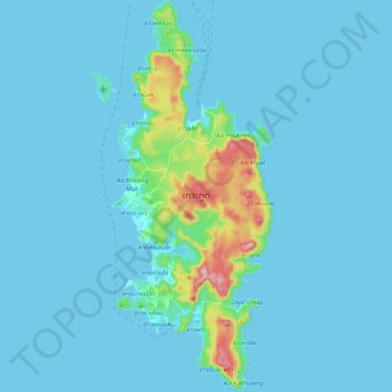
Name: Ko Kut topographic map, elevation, terrain.

Location: Ko Kut, Ao Salad, Ko Kut, Trat Province, Thailand (11.56152 102.52397 11.76233 102.60888)

Average elevation: 25 m

Minimum elevation: -1 m

Maximum elevation: 298 m

Gear up for your next adventure:

Camping Groundsheet - Protect your tent from moisture and dirt
👟Leg Gaiters - Keep debris, mud, and snow out of your boots
Camping Coffee Maker - Brew fresh coffee anywhere on the topographic map
🚲Heavy Duty Bike Lock - Secure your bike at the trailhead or during stops
🛁Quick-Dry Microfiber Towel - Space-saving towel that dries rapidly on the move

As an Amazon Associate, this site earns from qualifying purchases at no extra cost to you.