Geolocate

Halifax topographic map

Click on the map to display elevation.

About this map

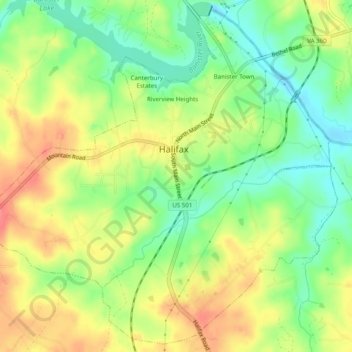
Name: Halifax topographic map, elevation, terrain.

Location: Halifax, Halifax County, Virginia, United States (36.74426 -78.95516 36.78189 -78.90582)

Average elevation: 130 m

Minimum elevation: 98 m

Maximum elevation: 163 m

Gear up for your next adventure:

🎒Hiking Daypack - Lightweight and durable backpacks for day trips and excursions
🥾Waterproof Hiking Boots - Essential footwear for rugged terrain and wet Canadian trails
🥽Outdoor Goggles - Protective eyewear for outdoor activities
🧭GPS Tracker - Track your location in remote areas safely
🧦Hiking Liner Socks - Thin base layer to prevent friction and blisters

As an Amazon Associate, this site earns from qualifying purchases at no extra cost to you.